
Importance of Accurate Geocoding
An often-overlooked component of catastrophe modeling is the geocoding accuracy of the risks being analyzed. Though catastrophe model vendors may have their own geocoding engines, they can lack accuracy and/or be outdated. An important consideration for companies using multiple catastrophe models is that the variance in the location that the risk is placed from different geocoders can be an unwanted contributing factor to expected model differences. Further, some perils, such as flood and wildfire, can be much more sensitive to slight derivations in geocoded latitude and longitude than other perils, like hail or winterstorm.
ACCURACY CAN BE A HARD METRIC TO MEASURE.
To assess the accuracy of several geocoding vendors, we analyzed 1,000 addresses in seven different geocoding vendors.
Do you consider which vendor had more Rooftop matches or less ZIP Code matches?
Further, while a particular vendor may have a higher number of Rooftop matches, some of these matches could be false. This is arguably the worst result as identifying false matches is onerous and tedious. There can also be challenges interpreting equivalence in how the vendors word their match levels to compare and group results. With that said, below was our approach to compare vendors based on reported match levels.

Vendor B had the most Rooftop/Parcel matches followed by vendor A. Vendor A had the least amount of ZIP Code matches while Vendor E had the most. All models were able to geocode each risk to at least the ZIP Code level. Note that vendor G does not have a Rooftop/Parcel match level. Assuming that there were no false matches to higher geocoding levels, Vendors A, B and D and are the clear winners, having the most risks in higher resolution geocoding buckets than the other vendors. Of course, accuracy shouldn’t be the only variable in selecting a geocoder. Geographic scope, speed, ease of use and pricing are also other factors to consider.
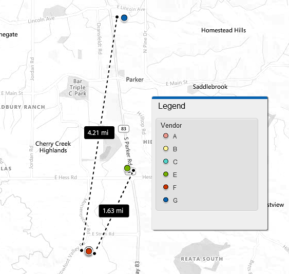
It can be beneficial to visually verify where a vendor places a geocoded point. To assist with this, we uploaded the geocoded points into our geospatial vendor, Insurity Geospatial. The below left graphic is an example of a risk where all vendors matched at the Rooftop or Street Address level. We wouldn’t expect much difference, if any, in modeled losses for each of these coordinates. The second example on the right identifies a risk where two vendors could not match to the Rooftop or Parcel levels. Instead, the risk was geocoded to a Relaxed Street Address and ZIP Code. Because of this, the risk was placed approximately 1.6 and 4.2 miles away from the actual location. The potential for location-derived model differences is greater in an instance like this.

The below use cases showcase the impact of inaccurate geocoding. The first use case relates to a portfolio geared towards newly built homes. Some geocoders can struggle with new properties, and the use case highlights the impact of geocoding on modeled California wildfire losses. The second use case looks at a location that has multiple buildings and the effect on modeled tornado losses if all buildings are aggregated into one single latitude/longitude versus having each building assigned its appropriate coordinates.
Use Case 1: Newly Built Homes
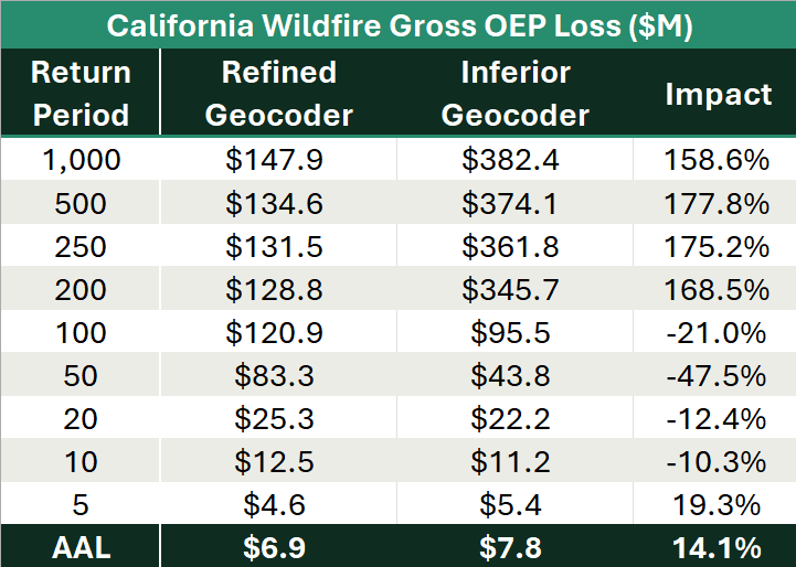
If a carrier writes many risks in a new development that, because of an outdated geocoder, get placed at the ZIP centroid, an artificial concentration can be created. Depending on the model and peril, these risks can be modeled as if they are all at the same coordinates. Below is an example comparing a more refined geocoder versus an inferior one analyzed for California wildfire in a catastrophe model. The more refined geocoder had 99% of the risks matched to the Rooftop or Address level while the inferior geocoded portfolio only had 29% of the risks geocoded to the Rooftop or Address level. Nearly 40% of the risks were geocoded to the ZIP Code level in the inferior geocoder. Looking at the losses, there is an interesting paradox that occurs. Losses based on the inferior geocoder are much higher at the upper return periods (>100 year) as events are impacting an artificially high number of risks that are placed at the same latitude and longitude. Incredibly, the 1:250 PML is more than 175% higher than the results based on the more refined geocoder. Alternatively, because there are fewer overall distinct locations from the inferior geocoder, the previously small and medium events are impacting less exposure as seen in the decreased impact from the 1:10 to 1:100-year events.
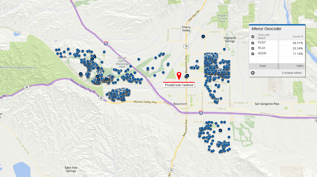
The below screenshot encapsulates this phenomenon. It shows one ZIP Code in which 69% of the risks were geocoded to the Postal Code level and modeled at a single point shown in red below.
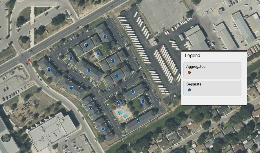
Use Case 2: Multi-Building Locations
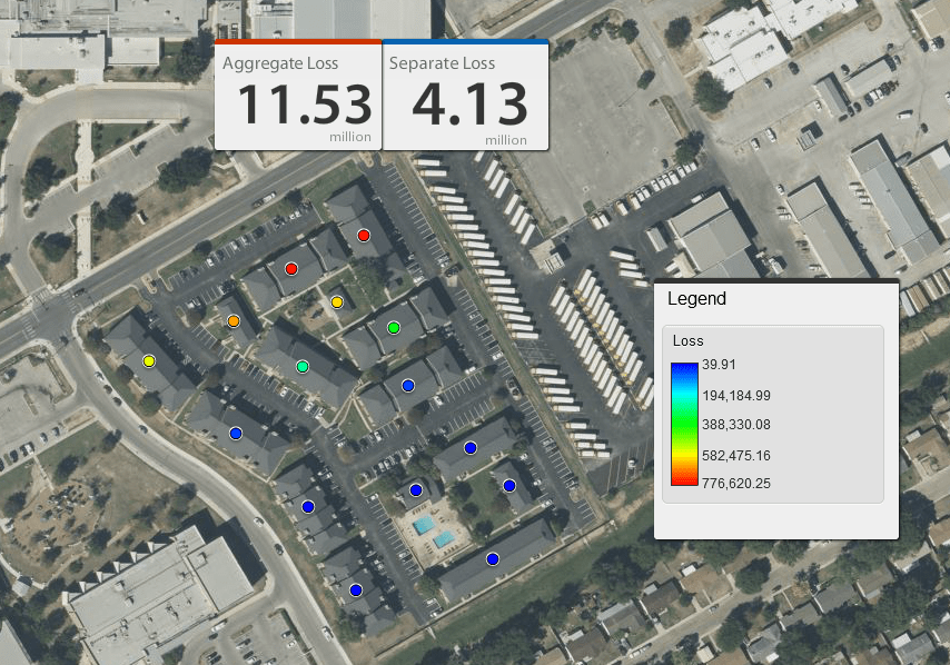
Geocoding can be of great significance for portfolios with a small number of risks and for individual policy evaluation, especially when modeled for location sensitive perils like wildfire, flood, and tornado. The below screenshot looks at one location with 15 buildings. This location was analyzed as if the information was aggregated using the coordinates of the red dot despite the existence of multiple buildings.
In the model event set, the aggregated point was impacted by a tornado event that caused a near total loss. When accurately assigning latitude and longitude points to each building, that loss dropped by nearly 66%. The strong winds of the tornado impacted the northwest portion of the property as shown in the graphic below. This left several points in the southeast portion of the property with very little impact. While capturing individual building information can be challenging, it can be worth the effort and can allow for a better assessment of potential extreme events.
Juniper Re Catastrophe Modeling Insights:
Accurate geocoding, or lack thereof, can have a large impact on results depending on the peril and makeup of the portfolio. Another important factor with respect to accurate geocoding is the perception among reinsurers, regulators, and rating agencies. Poor geocoding can raise alarms regarding data quality. If many risks are not geocoded to the Rooftop level, how confident can those assessing the portfolio be in the other facets of the modeling data such as risk characteristics? When geocoding is of the utmost importance, a potential strategy for a carrier or MGA to employ is to have a geocoder in 1st position. Any unmatched record will go to a geocoder that sits in 2nd position and so on depending on your desired balance of cost and accuracy.
Every company has a unique set of goals and challenges. Working with a trusted advisor who can provide guidance on the different facets of the catastrophe models is imperative. Juniper Re can help integrate a tailored view of risk, which can lead to more appropriate pricing and better-informed risk management decisions.